
Visit To Hawaii - Page 2
 This is a picture of the ruins called: Kaniakapupu, which was the summer palace of King Kamehameha III. Just click on the name above for more details about these ruins. And by the way, although the web page says that there is a 70-foot waterfall towards the back of area, Dave and I went back there and it was nothing more than a stone wall and a dried-out pond. Unfortunately, the area is suffering from a drought, so most of the flowing waters seen around Oahu just weren't flowing.
 Nearby the entrance to the trail through the bamboo, we came across some flowers. Not sure which ones these are, but they were quite interesting.
 Now, about this trail through the bamboo... Since this site is considered to be sacred, it is not advertised as a visitor's site, and the only reason we found out about it was because a Hawaiian geocacher placed a container nearby the site in order for geocachers to see this special location. The geocache's web page was full of instructions telling geo-visitors to give the site its due respect, and you see, the opening is not easily visible when driving down the road. This is because the trail leads away at an angle from the road and all you see is the bamboo. Only by approaching on the opening on a small footpath (to the left of the elephant-ear plants in the bottom of the picture) can you see the opening of the trail, which veers off to the left. Obviously, the ruins are carefully concealed from a casually-curious mind driving by.
 We made our way down the bamboo path (we being Luann, Karen & I, since Dave took off like a shot), and the geocache instructions told us to turn left after about 350 feet. Since Dave was too far away to here us, he went straight and wound up back by the car. When we finally made contact with him via cellphone, he came back up the trail and made the requisite left-hand turn. When we got to the ruins, the trail broke into this clearing and this is what we saw. There are these plants lined up as though guiding you along the stone path to the front entrance of the building and a plaque explaining what this place is all about.
 A closer view of the plaque-wall shows how people have been placing items of reverance and gifts for the long-departed king on its base.
 And this is what the plaque has on it...
 The opportunities for floral images were immense.
 This was the point in our adventure where Luann was telling Dave that he should have turned left when he was coming up the trail. Meanwhile, I had my GPS out and was looking for the geocache.
 Ah, wild roses...
 Here is a view from the inside section of the ruins.
 Meanwhile, Luann took a picture of Karen taking a picture...
 Dave and I surveyed the remains of the outdoor kitchen area.
 When we reached the edge of the clearing, we came across these ginger flowers growing from an area that was recently mowed down by the grounds-keeping crew. Somehow, they missed this patch in the bushes, so we picked a few of them and gave them to the girls. The neat thing about this is that we left the flowers in the rental car and it smelled like ginger inside for a couple of days.
 So, do you think Karen is having fun? The walking stick in her hand is a piece of bamboo we picked up on our way in. We carried that thing all over with us, but there was no way we could take it back with us, so we had to leave it behind in the trunk of the rental car when we dropped it off.
 On our way back to the car, there was this little bit of a stream running towards a municipal water collection cistern. Yeah, this was about it when it came to finding a waterfall while we were out here, but it was kinda neat though.
 And I just couldn't help but to snap a shot of this flower (although I have no idea what this one is).
 After leaving the ruins, we made our way around the east side of the island up to the North Shore and stopped here on our way to do a little trinket shopping.
 Somewhere along the way, Luann picked up this neat purse made out of a coconut shell.
 This is Mokolii Island, also known locally as Chinaman's Hat. It was one of the features of Oahu that Karen wanted to see up close.
 Next, we cruised on down to a little piece of beach near a geocache that we wanted to stop at. While we were at the beach playing around a bit, Dave cracked open this coconut and we drank some of the water inside. Karen said it tasted fresh and clean. After that, we picked a couple of flowers, a piece of bleached seaweed, some worm-ridden driftwood and set up this shot.
 A brief pause to absorb the sights and sounds around us, then it was time to cross the street...
 ...to the Shrimp Shack, a mobile facility reknowned for its seafood. Oh, and a geocache.
 Of course, I was only there for the food...
 We asked the owners to pose with us while we took this picture, and they graciously obliged.
 Where are we from? Uhm... Right there!
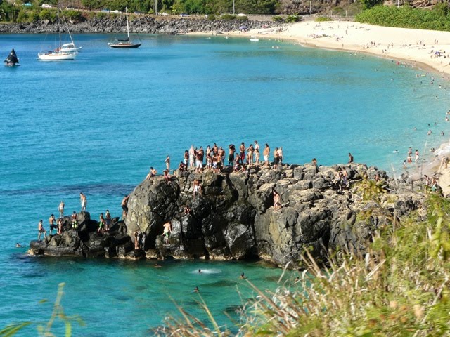 Back on the road again, we are still headed towards North shore to get some sunset shots. Luann got this shot over her shoulder as we drop by. Seems like a favorite spot for the teenagers to dive off the cliffs.
posted by The Nieborgs | 9/09/2010 12:48:00 PM
![]()
![]()
0 Comments:
Post a Comment
Subscribe to Post Comments [Atom]
<< Home